[Previous] | [Session 19] | [Next]
L. K. Tamppari (JPL/Caltech), P.R. Christensen (Arizona State University), J.C. Pearl (NASA Goddard Space Flight Center)
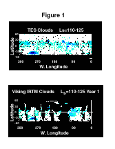
Over the past decade there has been an increased interest in Martian water-ice clouds and the role they play in the water-cycle (Clancy et al., 1996). One way to examine this question is to perform an interannual comparison of water-ice clouds. The Viking IRTM and MGS TES data sets offer the potential to do this globally, on year-long timescales. TES spectra are convolved to IRTM bandshapes and spatial resolutions (Fig. 1 top), and the water-ice cloud retrieval technique of Tamppari et al. (2000; Fig. 1 bottom) has been applied. The resulting cloud maps are directly comparable. The colors indicate: black=no data, white=data, but no water-ice clouds present, blues=clouds.
The maps have similar characteristics such as the aphelion cloud belt. Plate 2 in Pearl et al. (2001; covering Ls=106-141) shows increased opacity at the same locations as the strongest cloud signatures shown here. More map comparisons and results will be presented.
This work has been funded through the NASA Mars Data Analysis Program.